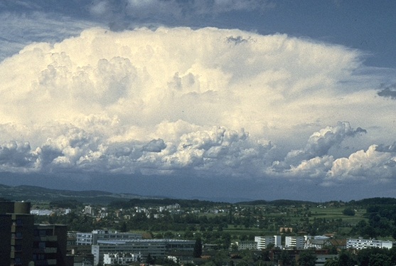
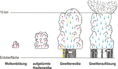
Images / Videos

Please enter a searchword.
The wind speed of a tropical storm is between force 8 and 11 on the Beaufort scale. If the wind force exceeds 11, the depression, depending on where it arises, is described as a hurricane (Atlantic, north-east Pacific), typhoon (north-west Pacific) or cyclone (Indian Ocean, south Pacific). Picture: Hurricane Lili, Louisiana, Earth Observatory USA 2002

Tropical storm

A tropical storm (wind force greater than 8) is a large low pressure area that arises over a tropical or sub-tropical ocean. Enormous cloud swirls form which can be almost 1000 km in diameter and last for periods ranging between...

Durch eien Rutschung zerstörte Strasse. Bild: Rutschung und Erosion Schlans, Bernhard Krummenacher 2002

Murgang Schlans (2002)

Der November 2002 war fast in der ganzen Schweiz ungewöhnlich feucht. Gemäss Messungen von MeteoSchweiz erreichte der Monatsniederschlag im Kanton Graubünden durchschnittlich 450% des langjährigen Mittels. Mehr als die Hälfte...

The ground floor of this building, whose upper section is adequately reinforced, has collapsed. Picture: Kobe earthquake, Hanshin (1), BWG 1995

Kobe earthquake 2 (1995)

The Great Hansin earthquake occured in Kobe, Japan, on 17 January 1995. The earth shook for around 20 seconds and the tremors reached a level of 7.3 on the Japanese JMA magnitude scale. The earthquake claimed the lives of...

Bed load deposits in the town of Brig following a log jam at a bridge. Picture: Debris flow Brig (1), Roberto Loat BAFU 1993

Brig flood (1993)

In September 1993, several weeks of constant rain were followed by three days of very intensive precipitation which resulted in the river Saltina bursting its banks in the town of Brig. After the flood, meteorologists calculated...

Durch starken Hagelschlag erlitten diese Tafeläpfel Totalschaden. Picture: Hagelschaden an Obstbäumen, Schweizer Hagel 2011.

Hail

Hail is solid precipitation in the form of balls or lumps of ice with a diameter in excess of 5 mm. The form and size of the hail stones and the intensity of their effects are influenced by climate, topography and wind...

The Stieregghütte mountain hut at the foot of the Lower Grindelwald Glacier stands on the unconsolidated ground of the glacier's moraine. The glacier, which previously supported the moraine, has shrunk significantly. As a result, landslides repeatedly occurred that literally pulled the ground from underneath the mountain hut restaurant which stood at an altitude of 1650 metres above sea level. Given the certainty that it was only a matter of time until the Stieregghütte ended up on the valley floor, it was decided to destroy the hut by burning it down. Picture: Lodge Stieregg Grindelwald (1), Hansruedi Burgener 2005

Grindelwald

Many glaciers are melting and retreating as a result of the increase in temperature. The rapide retreat of the Lower Grindelwald Glacier caused instability in the parts of the slope formed from moraine material above the former...

Picture: Staubwolke Randa, Andreas Götz PLANAT 1991

Randa rockslide (1991)

First rockslide

On 18 April 1991, around 15 million m3 of rock slid down to the valley near the town of Randa which is located in the Matter Valley. The rocks were the size of houses and the drop height was 600 metres.

The main...

Der höchste Berg Japans, mit 3776 Metern über Meer, ist ein Vulkan. Der letzte bekannte Ausbruch des Mount Fuji-san ereignete sich am 16. Dezember 1707. Dieser Schichtvulkan wird als aktiv eingestuft, mit einem geringen Risiko für einen Ausbruch. Bild: Mount Fuji-san, BWG 1990

Vulkane Asien

Vulkanismus befasst sich mit dem Aufsteigen von Material aus dem Erdinnern zur Erdoberfläche. Diese gasförmigen, flüssigen oder festen Stoffe treten aus Öffnugen in der Erdkruste aus, den sogenannten Vulkanen.


Das...

Collapsed apartment buildings Picture: Erdbeben Niigata Japan, NGDC USA 1980

Earthquake

Earthquakes are tremors or vibrations of the earth which originate in the earth's crust. There are three types of earthquakes: volcanic, explosion and tectonic earthquakes. The danger associated with earthquakes mainly arises...

Luftbild von der Siedlung Falli Hölli zu Beginn der Beschleunigung. Am oberen Quartierrand sind einige Häuser bereits zerstört. Im unteren Teil des Quartiers stehen die meisten Ferienhäuser noch. Das grosse Restaurant (unten) ist teilweise eingebrochen. Insgesamt sind 30 Millionen Kubikmeter Gestein abgerutscht. Picture: Luftbild Siedlung Falli Hölli, Hugo Raetzo BAFU 1994

Falli Hölli landslide (1994)

An old active slide slope in the Freiburg Pre-Alps accelerated unexpectedly in winter 1994. The Falli Hölli holiday house development in the commune of Plasselb and teh surrounding Alpine huts were completely destroyed by the...

Displaying results 1 to 10 out of 67
<< First < Previous 1-10 11-20 21-30 31-40 41-50 51-60 61-67 Next > Last >>